
 |
 |
 |
 |
As one alert reader observed, “fabulous pictures, and from what I have read, best taken from the ground.” |
But first: A quick review of stability |
Our atmosphere, the envelope of air surrounding the planet, is always in motion. We tend to think of the motion of our atmosphere as horizontal across the ground, namely wind. However, air can move vertically as well. An air mass, a large body of air that has nearly uniform characteristics of temperature and moisture, is classified as either stable or unstable. Stable air resists vertical motion. This is not to say that it cannot move vertically; rather, if it is disturbed by some outside force, and displaced vertically, it will not continue to move upward of its own accord. Again, stable air resists vertical motion. Conversely, unstable air, when disturbed vertically, will continue upward for some time, and possibly even accelerate vertically. |
Mechanical turbulence |
As air flows along the surface of the Earth, it encounters obstructions. These are man-made objects, such as buildings and bridges, and natural features, like hills, valleys, and mountains. All of them disrupt the flow of air into eddies. The strength of the eddies depends on the size of the object and the speed of the wind. It results in turbulence we classify as ‘mechanical’ because it is formed through the “mechanical disruption of the ambient wind flow”. Infact: “The degree of mechanical turbulence depends on wind speed and roughness of the obstructions. The higher the speed and/or the rougher the surface, the greater is the turbulence. The wind carries the turbulent eddies downstream – how far depends on the wind speed and the stability of the air. Unstable air allows larger eddies to form than those that form in stable air; but the instability breaks up the eddies quickly, while in stable air, they dissipate slowly.” page 82 Aviation Weather, AC 00-06A, 1975 
“As unstable air crosses the barrier, it spills down the leeward slope often as a violent downdraft. Sometimes the downward speed exceeds the maximum climb rate for your aircraft and may drive the craft into the mountainside. In the process of crossing the mountains, mixing reduces the instability to some extent. Therefore, hazardous turbulence in unstable air generally does not extend a great distance downwind from the barrier.” page 83 Aviation Weather, AC 00-06A, 1975 Think of it like this: If you throw a rock into the ocean where it’s crashing against the shore, you may end up with a bigger splash if the water from the splash combines with the wave at the right time, just as the wave breaks. You won’t get any ripples though because the wave’s action dissipates them. However, throw a rock into a serene lake and the ripples will propagate for a long distance! Unstable air is analogous to the choppy ocean along the shore, and stable air is similar to the lake. When unstable air is obstructed by a mountain, it intensifies the turbulence it produces on the windward side and along the crest. The turbulent air then violently descends on the leeward side. Pilots must be especially aware of this situation, as the picture shows, because the downward speed of the air can be very great! |
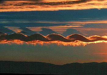
Mountain waves |

The figure above shows a cross section of the standing wave pattern that forms downwind of a mountain as a result of stable airflow across the crest. “When stable air crosses a mountain barrier…air flowing up the windward side is relatively smooth. Wind flow across the barrier is laminar – that is, it tends to flow in layers. The barrier may set up waves in these layers much as waves develop on a disturbed water surface. The waves remain nearly stationary while the wind blows rapidly through them. The wave pattern is a ‘standing’ or ‘mountain’ wave, so named because it remains essentially stationary and is associated with the mountain. The wave pattern may extend 100 miles or more downwind from the barrier.” Pages 83-84 Aviation Weather, AC 00-06A, 1975 Note how the wave pattern from a mountain wave extends not only horizontally for many miles, but also vertically. In fact, a mountain wave action and turbulence can affect aircraft at altitudes into the lower stratosphere, which typically begins around 30,000 to 35,000 feet above sea level! |
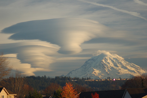
Clouds associated with mountain waves |
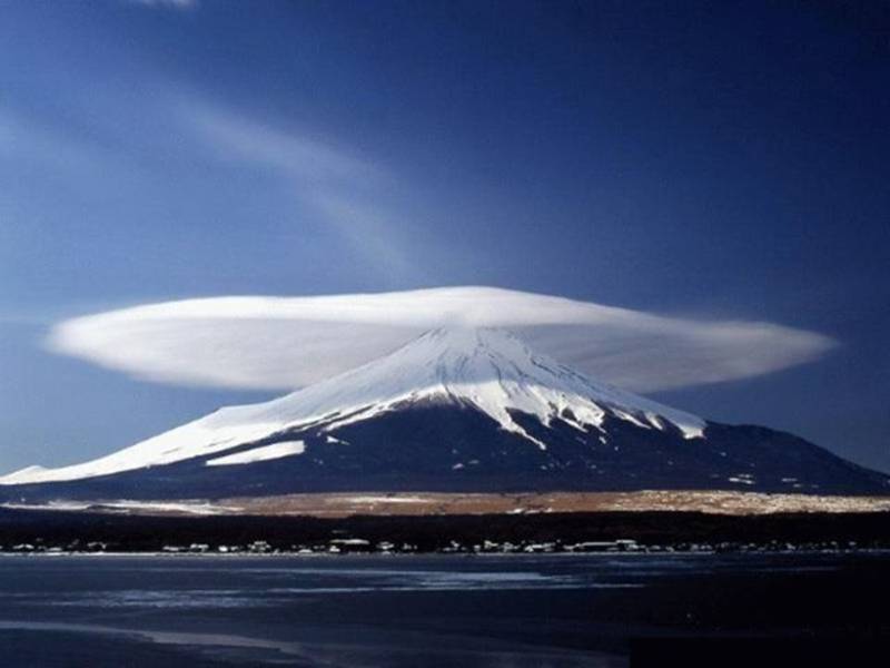
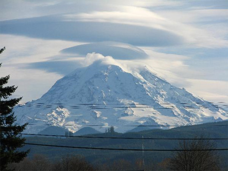
Photo taken south of Walsenburg, Colorado on May 20, 2003 If the air contains sufficient moisture where a mountain wave forms, there may be clouds which provide an indication of the mountain wave conditions. You may see a cap cloud directly over the mountain, as pictured above. Cap clouds indicate that there is a strong wind flow down the slope on the lee side of the mountain. You can imagine horizontal streams of air flowing over the mountain, as were diagramed above. Where the moist air cooled sufficiently as it rose to cross over the peak, the cap cloud formed. On the lee side, the air warmed as it descended back down the slope and the cloud dissipated. The potential for strong turbulence is certainly present when a cloud like this has formed. Rotor, or roll clouds (below) may be produced at approximately the height of the mountain top. Roll clouds are produced by the rotor circulation of air on the leeward side of the mountain below the wave crests - see the above diagram. This is the area of the greatest danger due to the extreme turbulence in and below rotor clouds. |
|
Images from: University of Colorado at Boulder Georgraphy Department |
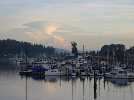
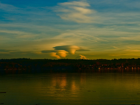
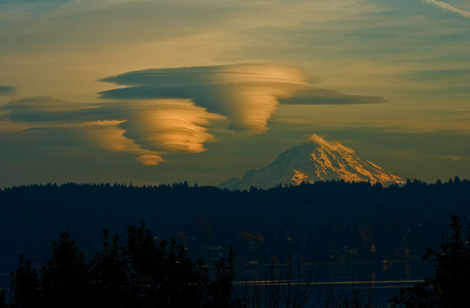
Finally, you may see standing lenticular clouds similar to those that appear at the beginning of this article and to the left. Standing lenticular clouds are lens shaped clouds, hence their name. Standing lenticular clouds form in the crests of the mountain wave where the rising updraft of the wave has cooled and moisture has condensed. The clouds dissipate in the downdrafts of the wave where the air has descended and warmed to the point where the moisture evaporates and is no longer visible. This is why the clouds are called “standing”. They stay in the crests of the mountain waves and do not move with the wind flow. Even standing lenticular clouds are classified by their altitude. You may recall that clouds are grouped into 4 families: Low, Middle, High, and Clouds with extensive vertical development. With respect to standing lenticular clouds, they are cumuliform clouds by nature and are considered middle (altocumulus standing lenticular) and high (cirrocumulus standing lenticular), thus the abbreviations ACSL and CCSL in the diagram above. |
Points to remember |
A few items to keep in mind as you begin training to fly in mountains (or study for a knowledge exam):
|
Article by: Terry Keller Jr. |